Archaeological Remote Sensing
The Programme Line ‘Archaeological Remote Sensing’ is focussing on the development and application of archaeological remote sensing as the main method for large-scale archaeological site detection and identification.
Geo-referenced and rectified vertical and oblique aerial photos obtained through reconnaissance flights as well as airborne remote sensing data are used to derive an integrated archaeological mapping and interpretation of detected structures or features. In this way, repetitive observations can be combined into an extensive overall view of an archaeological region, which will be used as basic information for the application of additional prospection methods, targeted excavations, protection measures and spatial archaeology.
The main objectives of this programm line are the further development of archaeological airborne laser scanning, the systematic evaluation of airborne hyper-spectral scanning data for aerial archaeology and the acceleration as well as the semi-automatic rectification and geo-referencing of aerial imagery.
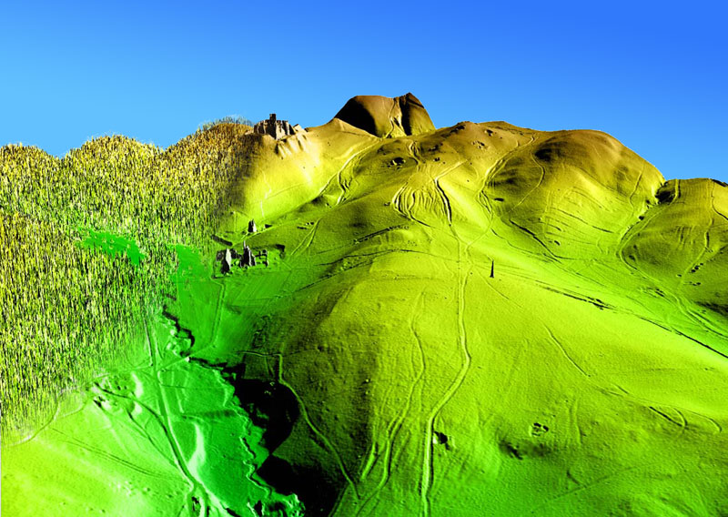
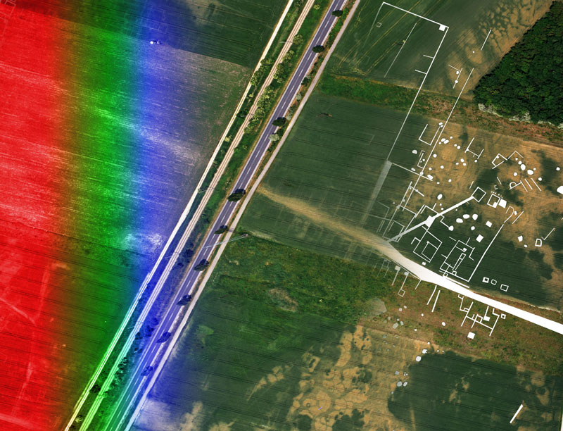
Aerial archaeology / aerial remote sensing is a very cost-effective method for site discovery with the potential to provide detailed maps of archaeological structures, showing up on the surface as so called “visibility marks”, i.e. slight topographic variations visible as shadow-marks, soil-marks due to varying chemical and physical properties affecting soil colour on the surface, and crop-marks due to variable growth of the vegetation or frost-marks due to varying thermal properties. Georeferenced and rectified vertical and oblique aerial photos from reconnaissance flights are used to derive the archaeological interpretation of detected structures or features. In this way, repetitive observations can be combined into an extensive overall view of an archaeological region, which will be used as basic information for further prospecting, excavations, protection measures, and spatial archaeology.
Archaeological Remote Sensing Related Publications
2013
- Briese, C.; Doneus, M.; Verhoeven, G. (2013): Radiometric calibration of ALS data for archaeological Interpretation. In: W. Neubauer, I. Trinks, R. B. Salisbury and C. Einwögerer (Eds.): Archaeological Prospection. Proceedings of the 10th International Conference on Archaeological Prospection. Wien, Austria, 29.05.-02.06.2013. Wien: Verl. der Österr. Akad. d. Wiss., S. 427–429.
- Briese, C.; Glira, P.; Pfeifer, N. (2013): Integration of multi-temporal airborne and terrestrial laser scanning data for the analysis and modelling of proglacial geomorphodynamic processes. In: Geophysical Research Abstracts. An Open Access Publication for Abstracts of the Earth, Planetary and Space Sciences, Bd. 15. 10th EGU General Assembly. Vienna, Austria, 07.-12.04.2013. Abstract and poster.
- Briese, C.; Pfennigbauer, M.; Ulrich, A.; Doneus, M. (2013): Multi-Wavelength Airborne Laser Scanning for Archaeological Prospection. In: P. Grussenmeyer (Ed.): XXIV International CIPA Symposium. Strasbourg, France, 02.-06.2013 (ISPRS Archives, XL-5/W2), S. 175–180. Online available at http://www.int-arch-photogramm-remote-sens-spatial-inf-sci.net/XL-5-W2/1….
- Doneus, M. (2013): Airborne Laser Scanning and archaeological interpretation – bringing back the people. In: R. S. Opitz and D. C. Cowley (Eds.): Interpreting Archaeological Topography – airborne laser scanning, 3D data and ground observation: Oxbow (Oxbow Books), S. 32–50.
- Doneus, M.; Doneus, N.; Briese, C.; Pregesbauer, M.; Mandlburger, G.; Verhoeven, G.; Miholjek, I.; Daim, F. (2013): Measuring the topography of submerged archaeological sites from the air. In: W. Neubauer, I. Trinks, R. B. Salisbury and C. Einwögerer (Eds.): Archaeological Prospection. Proceedings of the 10th International Conference on Archaeological Prospection. Wien, Austria, 29.05.-02.06.2013. Wien: Verl. der Österr. Akad. d. Wiss., S. 16–18.
- Doneus, M.; Draganits, E.; Gansum, T. (2013): The Viking-age royal burial site of Borre (Norway): LiDAR-based landscape reconstruction and harbour location at an uplifting coastal area. In: W. Neubauer, I. Trinks, R. B. Salisbury and C. Einwögerer (Eds.): Archaeological Prospection. Proceedings of the 10th International Conference on Archaeological Prospection. Wien, Austria, 29.05.-02.06.2013. Wien: Verl. der Österr. Akad. d. Wiss., S. 36–38.
- Doneus, M.; Fornwagner, U.; Kiedl, C. (2013): APIS – Archaeological Prospection Information System. In: W. Neubauer, I. Trinks, R. B. Salisbury and C. Einwögerer (Eds.): Archaeological Prospection. Proceedings of the 10th International Conference on Archaeological Prospection. Wien, Austria, 29.05.-02.06.2013. Wien: Verl. der Österr. Akad. d. Wiss., S. 317–318.
- Draganits, E.; Doneus, M.; Gansum, T. (2013): LIDAR-based coastal landscape reconstruction and harbour location: The Viking-age royal burial site of Borre (Norway). In: Geophysical Research Abstracts. An Open Access Publication for Abstracts of the Earth, Planetary and Space Sciences, Bd. 15. 10th EGU General Assembly. Vienna, Austria, 07.-12.04.2013. Abstract and lecture.
- Glira, P.; Briese, C.; Kamp, N.; Pfeifer, N. (2013): Simultaneous relative and absolute orientation of point clouds with „TLS radomes”. In: Geophysical Research Abstracts. An Open Access Publication for Abstracts of the Earth, Planetary and Space Sciences, Bd. 15. 10th EGU General Assembly. Vienna, Austria, 07.-12.04.2013. Abstract and lecture.
- Karel, W.; Doneus, M.; Verhoeven, G.; Briese, C.; Ressl, C.; Pfeifer, N. (2013): Oriental – Automatic Geo-Referencing And Ortho-Rectification Of Archaeological Aerial Photographs. In: P. Grussenmeyer (Ed.): TC V. XXIV International CIPA Symposium. Strasbourg, France, 02.-06.09.2013 (ISPRS Annals, II-5/W1). Online available at http://www.isprs-ann-photogramm-remote-sens-spatial-inf-sci.net/II-5-W1/….
- Klimcyk, A.; Doneus, M.; Briese, C.; Pfeifer, N. (2013): Evaluation of different software packages for ALS filtering. In: W. Neubauer, I. Trinks, R. B. Salisbury and C. Einwögerer (Eds.): Archaeological Prospection. Proceedings of the 10th International Conference on Archaeological Prospection. Wien, Austria, 29.05.-02.06.2013. Wien: Verl. der Österr. Akad. d. Wiss., S. 363–366.
- Kucera, M.; Sevara, C.; Trinks, I.; Ling, J. (2013): Towards the Rapid Documentation of the Tanum Landscape: Developing an integrated workflow using 3D laser scanning and image based modelling techniques. In: W. Neubauer, I. Trinks, R. B. Salisbury and C. Einwögerer (Eds.): Archaeological Prospection. Proceedings of the 10th International Conference on Archaeological Prospection. Wien, Austria, 29.05.-02.06.2013. Wien: Verl. der Österr. Akad. d. Wiss., S. 357–358.
- Michel, R.F.M.; Schaefer, C.; Simas, F.; Pregesbauer, M.; Bockheim, J. (2013): Active layer thermal monitoring at Fildes Peninsula, King George Island, Maritime Antarctica. In: Geophysical Research Abstracts. An Open Access Publication for Abstracts of the Earth, Planetary and Space Sciences, Bd. 15. 10th EGU General Assembly. Vienna, Austria, 07.-12.04.2013. Abstract and lecture.
- Morsdorf, F.; Pfeifer, N.; Briese, C.; Wagner, W. (submitted): LiDAR pulse interaction with forest canopy – geometric and radiometric issues. In: Forestry applications of airborne laser scanning – Concepts and Case Studies.
- Neubauer, W.; Flöry S.; Trinks, I.; Hinterleitner, A.; Löcker, K.; Seren, S. (2013): High-resolution multi-channel GPR survey of the Roman town Flavia Solva in Austria. In: W. Neubauer, I. Trinks, R. B. Salisbury and C. Einwögerer (Eds.): Archaeological Prospection. Proceedings of the 10th International Conference on Archaeological Prospection. Wien, Austria, 29.05.-02.06.2013. Wien: Verl. der Österr. Akad. d. Wiss., S. 171–172.
- Neubauer, W.; Flöry S.; Zitz, T.; Nau, E.; Löcker, K. (2013): Relocation of a partly excavated Roman Villa Rustica by geophysical prospection. In: W. Neubauer, I. Trinks, R. B. Salisbury and C. Einwögerer (Eds.): Archaeological Prospection. Proceedings of the 10th International Conference on Archaeological Prospection. Wien, Austria, 29.05.-02.06.2013. Wien: Verl. der Österr. Akad. d. Wiss., S. 349.
- Pregesbauer, M. (2013): Object versus Pixel – Classification Techniques for high resolution airborne remote sensing data. In: W. Neubauer, I. Trinks, R. B. Salisbury and C. Einwögerer (Eds.): Archaeological Prospection. Proceedings of the 10th International Conference on Archaeological Prospection. Wien, Austria, 29.05.-02.06.2013. Wien: Verl. der Österr. Akad. d. Wiss., S. 200–202.
- Pregesbauer, M.; Michel, R.F.M.; Kabelik, B.; Altenberger, A.; Rathmanner, M. (2013): A comparative study on new technologies for mapping glaciers and snow fields. In: Geophysical Research Abstracts. An Open Access Publication for Abstracts of the Earth, Planetary and Space Sciences, Bd. 15. 10th EGU General Assembly. Vienna, Austria, 07.-12.04.2013. Abstract and lecture.
- Risbøl, O.; Briese, C.; Doneus, M.; Nesbakken, A. (2013): Identifying and documenting landscape changes by the use of multi-temporal historical aerial photos and ALS-generated DEMs – an automated and retrospective approach. In: W. Neubauer, I. Trinks, R. B. Salisbury and C. Einwögerer (Eds.): Archaeological Prospection. Proceedings of the 10th International Conference on Archaeological Prospection. Wien, Austria, 29.05.-02.06.2013. Wien: Verl. der Österr. Akad. d. Wiss., S. 11–12.
- Roncat, A.; Briese, C.; Jansa, J.; Pfeifer, N. (submitted): Radiometrically Calibrated Features of Full-Waveform Lidar Point Clouds based on Statistical Moments. In: IEEE GRSL.
- Studnicka, N.; Briese, C.; Verhoeven, G.; Kucera, M.; Zach, Gerald; Ressl, C.(2013): The Roman Heidentor as study object to compare mobile laser scanning data and multi-view image reconstruction. In: W. Neubauer, I. Trinks, R. B. Salisbury and C. Einwögerer (Eds.): Archaeological Prospection. Proceedings of the 10th International Conference on Archaeological Prospection. Wien, Austria, 29.05.-02.06.2013. Wien: Verl. der Österr. Akad. d. Wiss., S. 25–28.
- Taelman, D.; Verhoeven, G.; Vermeulen, F. (2013): Computer vision-based orthophotomapping of complex archaeological sites: The ancient quarry of Pitaranha (Portugal–Spain). Unter Mitarbeit von Ghent University – 7Reasons. In: F. Vermeulen and C. Corsi (Eds.): Non-destructive approaches to complex archaeological sites in Europe: a round-up. Proceedings of the Radio-Past Colloquium. S. 103–104, Ghent, Belgium, 15-17 January 2013. Ghent: Ghent University, Department of Civil Engineering. Abstract and poster.
- Zlinszky, A.; Ressl, C.; Timár, G.; Weber, R.; Székely, B.; Briese, C.; Pfeifer, N. (2013): A proof of concept: Airborne LIDAR-measured ellipsoidal heights of a lake surface correspond to a local geoid model. In: Geophysical Research Abstracts. An Open Access Publication for Abstracts of the Earth, Planetary and Space Sciences, Bd. 15. 10th EGU General Assembly. Vienna, Austria, 07.-12.04.2013. Abstract and lecture.
- Zlinszky, A.; Timár, G.; Weber, R.; Székely, B.; Briese, C. (submitted): Observation of a local gravity isosurface by airborne LIDAR. In: Nature Geosciences.
2012
- Briese, C.; Doneus, M.; Verhoeven, G. (2012): The spectral dimension of a point cloud – finding crop marks in radiometrically calibrated ALS data. In: EARSeL Workshop 2012 Ghent. Advances in Remote Sensing for Archaeology and Cultural Heritage Management. Programme and Book of Abstracts. EARSeL. Ghent, S. 20–21. Abstract and lecture.
- Briese, C.; Pfennigbauer, M.; Lehner, H.; Ullrich, A.; Wagner, W.; Pfeifer, N. (2012): Radiometric Calibration Of Multi-Wavelength Airborne Laser Scanning Data. In: M. R. Shortis, W. Wagner and J. Hyyppä (Eds.): XXII ISPRS Congress, Technical Commission VII, 1-7. Imaging a Sustainable Future. Melbourne, Australia, 25.08.-01.09.2012. ISPRS: ISPRS (ISPRS Ann. Photogramm. Remote Sens. Spatial Inf. Sci., 1-7), S. 335–340.
- Briese, C.; Pfennigbauer, M.; Ullrich, A.; Pfeifer, N. (2012): Radiometric Analysis of Multi-Wavelength Airborne Laser Scanning Data of Different Case Study. In: Silvilaser 2012. 12th International Conference on LiDAR Applications for Assessing Forest Ecosystems. Vancouver, Canada, 16.-19.09.2012, S. 128. Online available at http://silvilaser2012.com/wp-content/uploads/2011/11/Silvilaser2012_Prog…. Abstract and lecture.
- Briese, C.; Zach, G.; Verhoeven, G.; Ressl, C.; Ullrich, A.; Studnicka, N.; Doneus, M. (2012): Analysis of mobile laser scanning data and multi-view image reconstruction. In: M. R. Shortis and J. Mills (Eds.): Proceedings of the XXII ISPRS Congress, Vol. XXXIX- B5. Imaging a Sustainable Future. Melbourne, Australia, 25.08.-01.09.2012. ISPRS: ISPRS (ISPRS Archives, Volume XXXIX), S. 163–168.
- Doneus, M. (2012): Airborne, ground based and underwater – advancing integrated archaeological prospection. EARSeL Workshop: Advances in Remote Sensing for Archaeology and Cultural Heritage Management. Uni Ghent, EARSeL. Ghent, Belgien, 19.09.2012.
- Doneus, M.; Pregesbauer, M.; Briese, C.; Doneus, N. (2012): ALB – Airborne laser bathymetry: surveying underwater topography. In: Aerial Archaeology, Remote Sensing and the Archaeological Process (AARG 2012). Budapest, Hungary. Programme and Abstract volume. Budapest. Abstract and lecture.
- Doneus, M.; Verhoeven, G.; Pregesbauer, M.; Briese, C.; Trinks, I.; Rathmanner, M. (2012): Advanced archaeological airborne remote sensing. In: The First International Conference «Virtual Archaeology-2012«. Program and abstracts. Saint-Petersburg (Russian Federation), 04.-06.06.2012, S. 35. Abstract and lecture.
- Fera, M.; Neubauer, W.; Doneus, M. (2012): 3D documentation and visualization of stratigraphic excavations. In: The First International Conference «Virtual Archaeology-2012«. Program and abstracts. Saint-Petersburg (Russian Federation), 04.-06.06.2012, S. 28. Abstract and lecture.
- Kucera, M.; Nau, E.; Kastowsky, K.; Schneidhofer, P.; Fera, M. (2012): Terrestrial 3D laser scanning in archaeology. In: The First International Conference «Virtual Archaeology-2012«. Program and abstracts. Saint-Petersburg (Russian Federation), 04.-06.06.2012, S. 36. Abstract and lecture.
- Pfeifer, N.; Glira, P.; Briese, C. (2012): Direct Georeferencing With On Board Navigation Components Of Light Weight UAV Platforms. In: M. R. Shortis and J. Mills (Eds.): Proceedings of the XXII ISPRS Congress, Vol. XXXIX-B7. Imaging a Sustainable Future. Melbourne, Australia, 25.08.-01.09.2012. ISPRS: ISPRS (ISPRS Archives, Volume XXXIX), S. 487–492. Online available at http://www.int-arch-photogramm-remote-sens-spatial-inf-sci.net/XXXIX-B7/….
- Verhoeven, G. (2012): Near-Infrared Aerial Crop Mark Archaeology: From its Historical Use to Current Digital Implementations. In: J Archaeol Method Theory 19 (1), S. 132–160. DOI: 10.1007/s10816-011-9104-5.
- Verhoeven, G. (2012): Straightforward archeological orthophotos from oblique aerial images. In: SPIE Newsroom. DOI: 10.1117/2.1201210.004506.
- Verhoeven, G.; Doneus, M.; Briese, C. (2012): Computer vision techniques: towards automated orthophoto production. In: AARGnews 44, S. 8–11.
- Verhoeven, G.; Doneus, M.; Briese, C.; Atzberger, C. (2012): Turning hyperspectral pixels into archaeological information. In: EARSeL Workshop 2012 Ghent. Advances in Remote Sensing for Archaeology and Cultural Heritage Management. Programme and Book of Abstracts. EARSeL. Ghent, S. 81–82. Abstract and lecture.
- Verhoeven, G.; Doneus, M.; Briese, C.; Atzberger, C. (2012): Turning Hyperspectral Pixels into Archaeological Information. In: Aerial Archaeology, Remote Sensing and the Archaeological Process (AARG 2012). Budapest, Hungary. Programme and Abstract volume. Budapest, S. 11. Abstract and lecture.
- Verhoeven, G.; Doneus, M.; Briese, C.; Neubauer, W.; Doneus, N.; Trinks; Hinterleitner, A.; Pregesbauer, M. (2012): Latest developments in remote sensing of Roman urban and rural sites in Austria. In: The Roman Archaeology Conference 22. Frankfurt am Main, Germany, 29.03 – 01.04.2012. Abstracts. Institutum Archeologicum Germanicum. Frankfurt am Main, S. 25–26. Abstract and lecture.
- Zlinszky, A.; Mücke, W.; Lehner, H.; Briese, C.; Pfeifer, N. (2012): Vegetation mapping from medium-density discrete echo Airborne Laser Scanning data: a case study of the Lake Balaton wetlands. Geophysical Research Abstracts, Vol. 14. In: European Geosciences Union General Assembly 2012. Geophysical Research Abstracts, Paper ID EGU2012-11539. Vienna, Austria, 22.-27.04.2012 (EGU2012-11539, Vol. 14). Online available at http://publik.tuwien.ac.at/files/PubDat_207793.pdf. Abstract and lecture.
2011
- Briese, C.; Glira, P. (2011): Reed mapping by unmanned aerial vehicles. In: E. Csaplovics and J. Schmidt (Eds.): International Symposium on Advanced Methods of Monitoring Reed Habitats in Europe. Berlin: Rhombos-Verlag, S. 121–130.
- Briese, C.; Lehner, H.; Pfeifer, N.; Roncat, A.; Sailer, R. (2011): Radiometric Calibration of Airborne Laser Scanning Data for the Analysis of Alpine Cryosphere and Periglacial Environment. Managing Alpine Future II. International Conference 2011. Poster, 21.11.2011.
- Doneus, M. (2011): Luftbildarchäologie im Hinterland des niederösterreichischen Limes. In: Denkmalpflegebroschüre 45, S. 27–29.
- Doneus, M.; Briese, C.; Klimczyk, A.; Verhoeven, G. (2011): Towards an advanced DTM generation in wooded areas for archaeological prospection. In: Ambitions and Realities. Remote Sensing for Archaeology, Research and Conservation (AARG 2011). Institute of Prehistory, Adam Mickiewicz University. Poznań, S. 16. Abstract and lecture.
- Doneus, M.; Gugl, C.; Verhoeven, G. (2011): Archaeological Airborne Remote Sensing in Roman Carnuntum. In: Museen der Stadt Wien – Stadtarchäologie (Ed.): The 16th International Conference on Cultural Heritage and New Technologies. 14.-16.11.2011. Vienna, Austria. Vienna. Online available at http://www.stadtarchaeologie.at/?page_id=3533http. Abstract and lecture.
- Doneus, M.; Verhoeven, G.; Fera, M.; Briese, C.; Kucera, M.; Neubauer, W. (2011): Assessing the Accuracy of a Semi-Automatic and Low-Cost Image-Based Modelling Approach for Documenting Archaeological Excavations. In: Museen der Stadt Wien – Stadtarchäologie (Ed.): The 16th International Conference on Cultural Heritage and New Technologies. 14.-16.11.2011. Vienna, Austria. Vienna. Online available at http://www.stadtarchaeologie.at/?page_id=3562. Abstract and lecture.
- Roncat, A.; Lehner, H.; Briese, C. (2011): Laser Pulse Variations And Their Influence On Radiometric Calibration Of Full-Waveform Laser Scanner Data. In: D. D. Lichti and A. F. Habib (Eds.): ISPRS Workshop Laser Scanning 2011, XXXVIII-5/W12. Calgary, Canada, 29.-31.08.2011 (ISPRS Ann. Photogramm. Remote Sens. Spatial Inf. Sci., XXXVIII-5/W12), S. 37–42. Online available at http://www.int-arch-photogramm-remote-sens-spatial-inf-sci.net/XXXVIII-5….
- Sailer, R.; Bollmann, E.; Briese, C.; Fischer, A.; Klug, C.; Krainer, K.; Pfeifer, N.; Schümberg, M.; Stötter, J. (2011): The quantification of changes in the alpine cryosphere and periglacial environment based on ALS data. Managing Alpine Future II. International Conference 2011. Abstract and lecture.
- Scheiblauer, C. Pregesbauer, M. (2011): Consolidated Visualization of Enormous 3D Scan Point Clouds with Scanopy. In: Museen der Stadt Wien – Stadtarchäologie (Ed.): The 16th International Conference on Cultural Heritage and New Technologies. 14.-16.11.2011. Vienna, Austria. Vienna, S. 242–247.
- Verhoeven, G. (2011): Taking computer vision aloft – Archaeological three-dimensional reconstructions from aerial photographs with PhotoScan. In: Archaeol. Prospect. 18 (1), S. 67–73. DOI: 10.1002/arp.399.
- Verhoeven, G.; Doneus, M. (2011): Balancing on the Borderline – a Low-cost Approach to Visualize the Red-edge Shift for the Benefit of Aerial Archaeology. In: Archaeol. Prospect. 18 (4), S. 267–278. DOI: 10.1002/arp.420.
- Verhoeven, G.; Doneus, M.; Briese, C. (2011): Towards Archaeologically Relevant Hyperspectral Sampling. In: 31st EARSeL Symposium. Remote Sensing and Geoinformation not only for Scientific Cooperation. Prague, Czech Republic, 30 May-2 June 2011. Symposium Program and Abstract Book. EARSeL, S. 16. Abstract and lecture.
2010
- Doneus, M. (2010): Flugzeuggetragenes Laserscanning in der archäologischen Prospektion. Neues zum Burgstall von Purbach am Neusiedlersee. In: Purbacher Jahrbuch 7, S. 39–53.
- Doneus, M.; Briese, C.; Studnicka, N. (2010): Analysis of Full-Waveform ALS Data by Simultaneously Acquired TLS Data: Towards an Advanced DTM Generation in Wooded Areas. In: W. Wagner and B. Székely (Eds.): 100 Years ISPRS, Advancing Remote Sensing Science. ISPRS Technical Commission VII Symposium. Vienna, 05.-07.07.2010 (The International Archives of Photogrammetry, Remote Sensing and Spatial Information Sciences, Vol. XXXVIII, Part 7B), S. 193–198.
- Lehner, H.; Briese, C. (2010): Radiometric calibration of Full-Waveform Airborne Laser Scanning Data based on natural surfaces. In: W. Wagner and B. Székely (Eds.): 100 Years ISPRS, Advancing Remote Sensing Science, Vol. XXXVIII, Part 7B. ISPRS Technical Commission VII Symposium. Vienna, 05.-07.07.2010 (The International Archives of Photogrammetry, Remote Sensing and Spatial Information Sciences, Vol. XXXVIII, Part 7B), S. 360–365.
- Mücke, W.; Hollaus, M.; Briese, C. (2010): Reed structure mapping in airborne laser scanning data. In: David Miranda, Juan Suárez and Rafael Crecente (Eds.): Operational tools in forestry using remote sensing techniques. ForestSat Conference 2010. Lugo, Spain, 06.-11.09.2010. ForestSat 2010. [S.l: s.n., S. 286–288.