Archaeological Interpretation, Spatial Analysis & Virtual Archaeology
Complex datasets demand adequate integrated archaeological interpretation and the development of novel concepts for dynamic analysis of archaeological landscapes, including temporal relations and further attributes.
Together with the newly acquired datasets, the pre-existing data archives of the LBI ArchPro partners demand adequate data management, data fusion and appropriate archaeological interpretation.
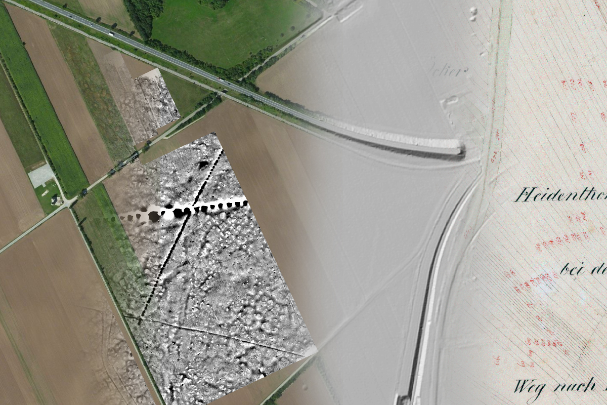
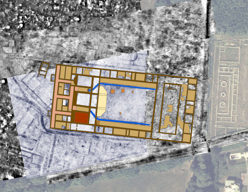
The main challenge of this LBI ArchPro research task is the transformation of the acquired and processed complex physical data from remote sensing and geophysical prospection into interpretative archaeological information that is accurate, readable and ready to use for other archaeologists in order to derive and integrate spatial and temporal information.
Both integrated interpretation of the data and spatial analysis for landscape archaeology, involve the development of appropriate spatial analysis algorithms for landscape archaeology and their application within the case studies. Such fundamental research will lead to the specification and implementation of general purpose tools for the spatial analysis applied to archaeological landscapes based on GIS technology. The specification of the individual GIS tools is derived empirically from the prospection experts’ interpretation process, which is simplified to an integrated, easy-to-use, multi-purpose toolbox within the ‘ArchaeoAnalyst’ software solution, providing a common graphical interface for the communication between the prospection experts and the archaeologists experienced in specific spatial or temporal aspects of the landscape under research.
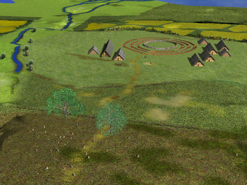
The empirical development of the ‘ArcheoAnalyst’ software is broken down into technical and methodological developments in parallel and their applications within the international case studies. These development steps are the setup of dynamic GIS-based data archiving and analysis system; the integrated archaeological interpretation of data; Spatial analysis for archaeology; the development of virtual reality tools for archaeological interpretation and the development of multi-scale data capturing for VR archaeological heritage representations.
Interpretation Spatial Analysis and Virtual Archaeology Related Publications
2013
- Doneus, M.; Griebl, M. (Eds.) (in Press): Die Leitha – Facetten einer archäologischen Landschaft. Wien: Verlag Österreichische Gesellschaft für Ur- und Frühgeschichte (Archäologie Österreichs Spezial).
- Doneus, M.; Gugl, C.; Doneus, N. (2013): Die Canabae von Carnuntum – ein Modell für römische Lagervorstädte? Von der Luftbildprospektion zur siedlungsarchäologischen Synthese: Verlag OAW (Römischer Limes in Österreich, 47).
- Doneus, M.; Kühtreiber, T. (2013): Landscape, the Individual and Society: Subjective Expected Utilities in a Monastic Landscape near Mannersdorf am Leithagebirge, Lower Austria. In: N. Mehler (Ed.): Historical Archaeology in Central Europe (Society of Historical Archaeology Special Publications, 9), S. 339–364.
- Doneus, N. (2013): From point to polygon – investigating a Roman rural landscape. In: W. Neubauer, I. Trinks, R. B. Salisbury and C. Einwögerer (Eds.): Archaeological Prospection. Proceedings of the 10th International Conference on Archaeological Prospection. Wien, Austria, 29.05.-02.06.2013. Wien: Verl. der Österr. Akad. d. Wiss., S. 197–199.
- Doneus, N. (in Press): Halbturn I – Ein römerzeitliches Gräberfeld aus dem Burgenland. Struktur und Grabrituale eines ländlichen Gräberfeldes im Hinterland von Carnuntum zwischen dem 2. und 5. Jh. In: N. Doneus (Eds.): Halbturn I. Das kaiserzeitliche Gräberfeld von Halbturn, Burgenland. Archäologie und Geschichte (Band 1), Intention, Abfall oder Zufall – naturwissenschaftliche Untersuchungen (Band 2). Mainz: Verlag Mainz (Monographien RGZM.
- Doneus, N. (In Press): Roman rural landscape in west Pannonia. A Case Study of the Roman Site at Halbturn, Austria (2nd – 5th centuries AD). In: Spatial Analysis Applied to Archaeological Sites from Protohistory to the Roman Period. Workshop on Spatial Archaeology at the Ghent University, Belgium. Ghent, Belgium, 02.-03.12.2010.
- Gugl, C.; Doneus, M.; Doneus, N. (in Press): The Canabae Legionis of Carnuntum: Modelling a Roman Urban Landscape from systematic, non-destructive Prospection and Excavation. In: Proceedings of the XXIst International Limes (Roman Frontiers) Congress 2009. Newcastle upon Tyne. Oxford (BAR International Series).
- Neubauer, W.; Gugl, C.; Scholz, M.; Verhoeven, G.; Trinks, I.; Löcker, K. Doneus, M.; van Meirvenne, M.; Saey, T. (in Press): The discovery of the school of gladiators at Carnuntum, Austria. In: Antiquity.
- Pregesbauer, M.; Stummer, B.; Humer, F. (2013): Digital Conservation of the Military Amphitheatre in Bad Deutsch Altenburg in the Province of Lower Austria. In: W. Neubauer, I. Trinks, R. B. Salisbury and C. Einwögerer (Eds.): Archaeological Prospection. Proceedings of the 10th International Conference on Archaeological Prospection. Wien, Austria, 29.05.-02.06.2013. Wien: Verl. der Österr. Akad. d. Wiss., S. 441–442.
- Carboni, F.; Vermeulen, F.; Monsieur, P.; Verhoeven, G. (2013): Potentia: integrated survey and mapping of a Roman colony on the Adriatic coast. In: F. Vermeulen and C. Corsi (Eds.): Non-destructive approaches to complex archaeological sites in Europe: a round-up. Proceedings of the Radio-Past Colloquium. Ghent, Belgium, 15-17 January 2013. Ghent: Ghent University, Department of Civil Engineering, S. 38–39. Abstract and lecture.
2012
- Gaffney, C.; Gaffney, V.; Neubauer, W.; Baldwin, E.; Chapman, H.; Garwood, P.; Moulden, H.; Sparrow, T.; Bates, R.; Löcker, K.; Hinterleitner, A.; Trinks, I.; Nau, E.; Zitz, T.; Floery, S.; Verhoeven, G.; Doneus, M. (2012): The Stonehenge Hidden Landscapes Project. In: Archaeol. Prospect. 19 (2), S. 147–155. DOI: 10.1002/arp.1422.
- Neubauer, W. (2012): Kreisgrabenanlagen – Middle Neolithic Ritual Enclosures in Austria 4800-4500 BC. In: A. Gibson (Ed.): Enclosing the Neolithic. Recent studies in Britain and Europe. Oxford: Archaeopress (BAR International Series, 2440).
- Neubauer, W.; Doneus, M.; Trinks, I.; Verhoeven, G.; Hinterleitner, A.; Humer, F.; Seren, S.; Löcker, K.; Nau, E. (2012): The Roman town of Carnuntum – an outstanding example of long-term integrated archaeological prospection. In: The Roman Archaeology Conference 22. Frankfurt am Main, Germany, 29.03 – 01.04.2012. Abstracts. Institutum Archeologicum Germanicum. Frankfurt am Main, S. 25. Abstract and lecture.
- Neubauer, W.; Nau, E.; Trinks, I.; Seren, Sirri; Löcker, K.; Klein, M. (2012): The school of gladiators at Carnuntum – virtual reconstruction based on archaeological prospection data. In: The First International Conference «Virtual Archaeology-2012«. Program and abstracts. Saint-Petersburg (Russian Federation), 04.-06.06.2012, S. 44. Abstract and lecture.
2011
- Gugl, C.; Doneus, M. (2011): Zur Wasserversorgung der Zivilstadt von Carnuntum. In: F. Humer and A. Konecny (Eds.): Römische Thermen – Forschung und Präsentation. Akten des internationalen Kolloquiums, veranstaltet vom Archäologischen Park Carnuntum und der Gesellschaft der Freunde Carnuntums 17.-18.09.2009. St. Pölten, S. 107–120.
- Gugl, C.; Doneus, M.; Humer, F.; Klein, M.; Paschke, V.; Weinlinger, G. (2011): Aus alten Ruinen wiedererstanden. In: E. Bruckmüller and F. Humer (Eds.): Erobern – Entdecken – Erleben im Römerland Carnuntum. Katalog zur Niederösterreichischen Landesausstellung 2011 ; 16. April – 15. November. Schallaburg: Schallaburg Kulturbetriebsges, S. 58–69.
2010
- Doneus, N. (2010): Am Rande der Gesellschaft? Römische Säuglings- und Kinderbestattungen aus dem Gräberfeld Halbturn I, Westpannonien. In: Mitt. Anthr. Gesellschaft (Mitteilungen Anthropologischen Gesellschaft) (140), S. 141–153.
- Heinrich, M.; Kollars, B.; Moshammer, B.; Rabeder, J.; Doneus, M. (2010): Aufnahme historischer Steinbrüche im Leithagebirge. In: Journal of Alpine Geology 52, S. 137–138.
- Neubauer, W. (2010): Archäologische Auswertung der systematischen Prospektion. In: P. Melichar and W. Neubauer (Eds.): Mittelneolithische Kreisgrabenanlagen in Niederösterreich. Geophysikalisch-archäologische Prospektion – ein interdisziplinäres Forschungsprojekt. Wien: Verl. der Österr. Akad. der Wiss. (Mitteilungen der Prähistorischen Kommission, 71), S. 56–135.
- Doneus, M. (2010): The Impact of Airborne Laser Scanning for Landscape Archaeology. In: CIMEC (Ed.): AARG 2010: International Aerial Archaeology Conference. Book of Abstracts, 15-18 September 2010. CIMEC; AARG. Bucharest: Institute for Cultural Memory, S. 18. Abstract and lecture.